|
Annals of Progress - The Story of Lenoir County & Kinston, NC by William S. Powell
In 1746 from a part of Craven County a new county was formed and named Johnston in honor of Gabriel Johnston, Governor of the Province. Johnston County included most of the territory now in Lenoir, Greene, Wayne, Wake, and, of course, Johnston counties. The act of the General Assembly establishing Johnston County directed that the new county court meet "at the Dwelling-house of Francis Stringer, at the Ferry, on Neuse River, and then and there nominate and appoint a certain place for building a court house, prison, and stocks at the most Proper Place in said County." Stringer's home and ferry were about two miles east of modern Kinston. County court was to meet on the last Tuesdays in March, June, September, and December each year. At the first sitting of the court, three persons were to be recommended to the Governor from whom he would select one to commission as sheriff. The law establishing Johnston County also set up St. Patrick's Parish of the Church of England with the same boundaries as the County. Vestrymen were appointed to serve until the next general election. More than merely a governing body for a church, the vestry attended to the needs of poor widows and orphans and generally served as the local government's welfare agency. The new County was allowed two representatives in the General Assembly. At its first meeting the county court selected a site for the courthouse and other public buildings on the eastern bank of Walnut Creek about eight miles southeast of present-day Goldsboro and about 18 miles west of Kinston. The courthouse was completed sufficiently for holding court by June, 1748. Ten years after Johnston County was formed the territory was divided into two parishes. Old St. Patrick's Parish remained in the eastern part of the County and new St. Stephen's Parish was in the west. Voters of the new parish were to meet at the courthouse at Walnut Creek to elect vestrymen while those of St Patrick's met at Samuel Smith's on Neuse River in the vicinity of modern Smithfield. This move was the first of several which resulted in the division of the large county of Johnston into several others, one of which became Lenoir. The selection of Walnut Creek as the county seat for Johnston County does not appear to have been a wise one. It was too remote and inaccessible. It lacked both inns and good camping grounds which had been available at Stringer's Ferry. People doing business at the county seat often had to remain several days. The courthouse was the only voting place in the County. Because of the distance many voters had to travel to cast their ballots, it became necessary to allow two days for an election. County court sessions in those days, before county fairs and circuses were known, were important social occasions which attracted a great many people. Even with all its drawbacks, Walnut Creek remained the seat of Johnston County until Dobbs County was formed in 1759, and then it became the seat of that county.
All the time the people were suffering the inconveniences of the county seat, the area around Stringer's Ferry continued to attract new settlers. Only two miles from the site of modern Kinston, it proved to be a center of religious, political, and economic growth during the eighteenth century. Francis Stringer, who began operating the ferry across the Neuse River here in 1737, was probably the first physician along this remote frontier. He had learned his skills at healing from his father and was the fourth generation of doctors in his family. Stringer was also a justice of the peace, a member of the General Assembly, and leading citizen of the community. It was not at all unusual in those days to find men who were outstanding in a number of activities. With a wilderness to conquer they had to be good at a variety of trades, and they seldom even thought twice about undertaking to build a house, heal the sick, hunt a wild turkey or bear, or clear a patch of new ground for a cornfield. Among Dr. Stringer's neighbors were Abraham Taylor and John Irons, both of whom also operated ferries across the Neuse, and James Mclllwean who owned 400 acres of land next to Stringer's.
In 1755 Governor Arthur Dobbs set out from New Bern on a trip up the Neuse River to look for a suitable site to establish a new seat of government for the province. North Carolina had never had a permanent capital. The offices of the Governor and other officials and all of the public records had been moved about from place to place as it suited the governor in office to establish his residence at some particular place. Some liked Edenton, some chose New Bern, and others thought Wilmington or Brunswick suitable. Dobbs traveled about a hundred miles above New Bern and carefully looked over the whole region. He selected a spot of high ground near Stringer's Ferry as the most suitable place for the new colonial capital. It was on the north bank of the Neuse River which was dry and free from the usual swampy shores. It was a healthful site with good springs to supply water. It lay about 50 miles above New Bern on a stream which was navigable for 60 to 80 miles and yet not overflowing the country in "great freshes."
The Governor, in reporting to his superiors in England, pointed out the importance of this central location, that it lay on a good road to New Bern, and that it could be reached from the Cape Fear area with only one ferry to be crossed. He thought the public officers of the colony should all reside here and that the members of the Council should have houses here and live in the capital at least a part of each year. He expected "that the Assembly will proceed briskly in erecting public buildings and offices which have been so long unsettled that almost all the old records are lost."
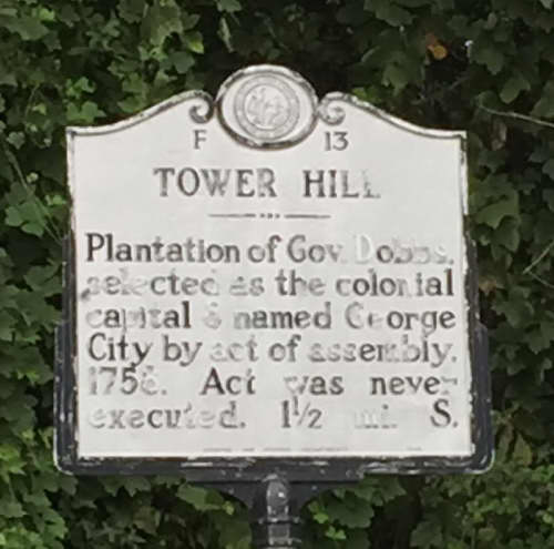 "Tower Hill - Plantation of Gov. Dobbs selected as the colonial capital & named George City by act of assembly, 1756. Act was never executed. 1 1/2 mi. S." In 1758 the Assembly approved Dobbs' recommendation and provided that the town should be called George City for King George II. It was to be built on 400 acres of the land and the remaining 450 acres were to be a town common. A home for the governor and a state house were planned as the first projects. A committee was appointed to arrange for the construction of the buildings and to lay off streets and one-half acre lots for sale to purchasers who were to erect houses of a certain size within five years. The committee was not to begin work until it was known whether Parliament would repay North Carolina for certain expenses in the French and Indian War. This far-sighted move was doomed, however. In spite of the attempt to honor the King by naming the city in his honor George III, who had succeeded his father in 1760, took no steps to approve the plans. In the colony the question of a location for the seat of government involved sectional interests and prestige. The oldest settled area, the Albemarle region had it own inteests to promote. New Bern had often been the seat of government and after 1762 Governor Dobbs established himself at Wilmington. As a result, George Town failed to develop as the capital of North Carolina. Instead, the Assembly in 1762 petitioned the Crown to designate New Bern as the capital. After much debate, New Bern won in 1766 and Governor Tryon began the construction of his palace. Dobbs' will, probated in 1765, left the Tower Hill land to his son, and after the Revolution it was claimed by the State of North Carolina as having been the property of a Tory. Capital or not, the area around Tower Hill continued to grow, although the formal establishment of a town was some years away.
In 1758 the General Assembly decided that Johnston County should be divided on April 10, 1759, to form a new county. This county was to be named Dobbs in honor of Governor Arthur Dobbs. Its boundaries were the same as those of St. Patrick's Parish when it had been in Johnston County. St. Patrick's now became the parish in the new county. The Assembly, in setting up Dobbs County, took note of the fact that "the large extent of the county of Johnston renders it grievous and burthensome to many of the Inhabitants thereof to attend the Courts and General Musters, and other Public Meetings." This was not a problem of Johnston County alone, however. It was true in many parts of the colony, particularly along the frontier. Large counties were created, and as the population increased, they were cut up into smaller and more manageable ones. Johnston County was given a new county seat at Hinton's Quarter on the south side of the Neuse, but Walnut Creek remained the official center of legal affairs for Dobbs County. The old Johnston County records were left in Dobbs County when the County began functioning in 1759. They were moved from Walnut Creek in 1779 when Kinston became the county seat. Modern Lenoir County, alone of the many counties created from the original Johnston County, can show historical continuity of records and county government functioning from 1746 to the present. Soon after the new Dobbs County officers began their duties, the General Assembly established three tobacco inspection warehouses in the County. One was at Atkins Bank on the land of William Heritage, another at Contentnea Creek on the land of Abraham Sheppard, and a third at Fellow's Ferry on the land of Robert Fellow. There were laws regulating the methods of packing tobacco for shipment and to prevent the sale of tobacco of inferior quality. Public warehouses, such as these, were established at various places throughout the colony, and unless tobacco received the approval of the inspectors, it could not be shipped out of the colony.
In December, 1762, the General Assembly passed an act to establish the town of Kingston on the land of William Heritage at Atkins Bank. The town was named to honor the young King George III who had ascended the throne just two years before. The name remained until 1784, after the Revolutionary War, when the "g" was dropped to show that the citizens of the town no longer desired to honor a king. The site was described as "a pleasant and healthy situation, and commodious for trade and commerce." Heritage consented to have 100 acres of his land laid off for a town and to devote 50 acres to a town common. Commissioners appointed to design the town were also instructed to take "subscriptions" for numbered lots. When 50 lots were spoken for, they were to hold a drawing and lots were to be assigned according to the number drawn. In order to keep a lot, the owner was required to build a frame or brick house at least 16 feet square with a brick or stone chimney within three years. Lots drawn but not built upon within three years were to become the property of anyone who would build the required house. If an owner died before building his house and without making other provisions for its disposition, the lot was to become the property of William Heritage or his heirs. Francis Mclllwean was appointed treasurer of the new town of Kingston. If he should move from Dobbs County, the remaining commissioners were authorized to appoint another treasurer. "Until the town should be incorporated the commissioners were to appoint a replacement for any of their body who died, moved, or failed to serve." Atkins Bank at which Kingston was established was not a village but merely the name applied to the bluff above the Neuse River because it was first granted to Robert Atkins. The original commissioners do not appear to have lived within the proposed bounds of the town. All but one of them, however, owned large tracts of land nearby. A warehouse for the inspection of tobacco already existed at the site, and since about 1748 there had been a chapel there, a Church of England mission served by a traveling missionary from New Bern or perhaps Edenton. The town was promptly laid out. The two principal streets were named for King George and Queen Charlotte. The boundary streets were named East, North, and South. On the west was the Neuse River. A street also was named in honor Governor Dobbs, but it later became Independent Street. Others were named in honor of the original commissioners of the town. The sale of lots seems to have gone slowly. By the end of 1763 only 19 had been taken. Just two years after the establishment of Kingston, Richard Caswell and Abraham Sheppard presented to the General Assembly a petition signed by a number of Dobbs County citizens urging that the new town be made the county seat "for the greater convenience of the people." A bill which was introduced for this purpose also provided that a portion of Craven County in the vicinity of Southwest Creek be added to Dobbs County. The change in boundaries was probably suggested to overcome the objections of some that Kingston would not otherwise be in the center of the County. Even with the support of the Craven County representative the whole bill was not passed. Only that part pertaining to the addition of a part of Craven to Dobbs was passed. The county seat was to remain at Walnut Creek. Efforts to revive the proposal for making Kingston the county seat failed at first. The action of the General Assembly was not to the liking of a good many of the leading citizens of Dobbs County. They continued to acknowledge Walnut Creek as the official county seat, of course, but they began to hold court at whatever location in the County seemed convenient at the time.
Efforts to divide Dobbs County were made on a number of occasions between 1767 and 1779. Finally, in the latter year, the General Assembly appointed five men to run a north-south line through the middle of Dobbs County. The eastern half was to remain Dobbs while the western half was named Wayne County. The Dobbs County courthouse was now to be in Kingston, but until a building could be erected the county court was directed to meet in the house formerly occupied by Colonel James Glasgow. A committee was promptly appointed to contract with workmen for the construction of a courthouse.
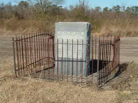 The following information is engraved on the marker standing at the former Dobbs County Court House site in the Walnut Creek area of Wayne County: "Dobbs County Court House, 1758-1791; The Following Counties Were Formed From Dobbs: Greene (Formerly Glasgow) 1779, Wayne 1779, Lenoir 1791 - Erected By The Wayne County Colonial Dames of America 1935"
|